
 Kenya Soil Survey, October 2009")

Agro-ecological zones (AEZs) are land units defined on the basis of combinations of soil, land form and climatic characteristics.
Introduction
Agro-ecological Zoning (AEZ) refers to the division of an area of lend into smaller units, which have similar characteristics related to land suitability, potential production and environmental impact. An Agro-ecological Zone is a land resource mapping unit, defined in terms of climate, landform and soils, and/or land cover, and having a specific range of potentials and constraints for land use. (FAO 1996).The essential elements in defining an agro-ecological zone are the growing period, temperature regime and soil mapping unit.
There are several systems for describing Agro-ecological zones in the Tropics. In Kenya two are used:
- FAO classification for tropics generally, and
- an older Kenya version which is only applicable in Kenya
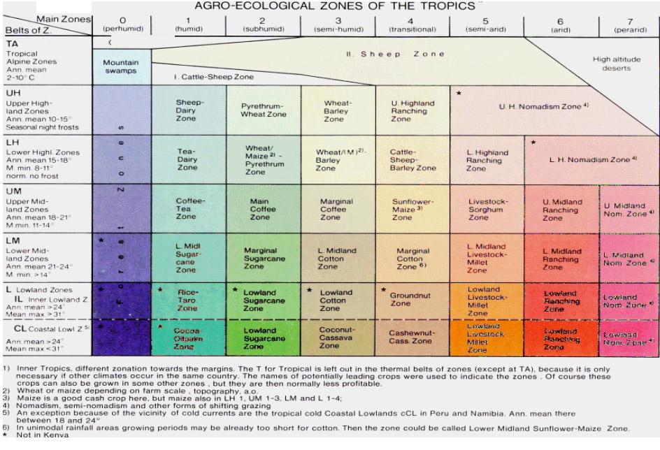
Classification of FAO Agro-Ecological Zones
Simple agro-ecological zones were established by FAO in 1981. They are suited to make decisions in international and long term agricultural policy. In order to give advice to farmers in the districts a more differentiated system showing yield probabilities and risks as well had to be developed:
1. Zone groups are temperature belts defined according to the maximum temperature limits within the main crops in Kenya can flourish; cashew and coconuts for the lowlands, sugar cane and cotton for the lower midlands, Arabica coffee for the upper midlands (usually known as "Highlands" - the term "midlands" is used here to denote their central importance), tea for the lower highlands, pyrethrum for the upper highlands. The highest zone is high altitude rough grazing i.e. tropical alpine (or afro-alpine) vegetation. The threshold values of annual mean temperatures have been established along similar lines but supplemented by limiting factors for many crops e.g. mean minimum temperatures, frost, etc.
2. Main zones are based on their probability of meeting the temperature and water requirements of the main leading crops. The name of the main zones refers to potentially leading crops and many of them can be grown in other zones too:
- Wheat in zones: UH 2-3; LH 2-4
- Maize zones: LH 1-3; UM 1-4; LM 1-4 (+5); L 2-4 (+5)
- Hybrid maize in zones: LH 1-3; UM 1-3; LM 1-3
- Unirrigated rice in zones: L 1-3; LM 1-2
- Irrigated rice in zones: L 1-6; (7); LM 1-6, (7)
- Sorghum in zones: UM (1-3), 4-5; LM (1-3), 4-5; L (1-3), 4-5
- Finger millet in zones: LH (1-3); UM (1-3), 4; LM (1-3), 4, (5); L (1-3), 4, (5)
- Groundnuts in zones: LM (1-2), 3-4; L (2-3), 4
- Cotton in zones: LM (2), 3-4; L (2), 3-4
( ) means that in these zones the crop is normally not competitive to related crops (f.i. dwarf millets to maize)
Natural potential of Kenyan agro-ecological zones (AEZs)
Agro-Ecological Zones 0-3 are originally zones of forest according to the natural vegetation.
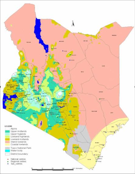
- AEZ 0 corresponds to ever wet evergreen rainforest
- AEZ 1 to evergreen rainforest
- AEZ 2 to seasonal rainforest because of one or two dry months
- AEZ 3 has three to five dry months, it corresponds to seasonal semi-deciduous moist forest or a high grass - broad leaved trees savanna
- AEZ 4 corresponds to woodland, it is either deciduous in subzone with unimodal rainfall as towards West Kenya and in Tanzania, or hard-leaved evergreen in bimodal rainfall subzones with two dry seasons as in East Kenya, where plants have hard or hairy leaves to avoid shedding them off twice a year. The grass is up to 1 m high.
- AEZ 5 - the natural vegetation in is a short grass savannah with small leafed thorny trees and bushes.
- AEZ 6 is bush land with very short but still perennial grass, therefore it is suitable for ranching - if the grass (the standing hay for the dry season) is not eradicated by overgrazing.
- AEZ 7 indicates Semi-desert
- AEZ 8 full desert
Implications of management on agro-ecological zones
Good management of the remaining natural vegetation by farmers especially herders is important:
- In AEZ 3 it is necessary to avoid burning which kills the regrowth of trees and ecologically valuable bushes. But the main danger here is overgrazing which puts the balance between grass and bushes to the bush side. Bush encroachment can finally finish the grazing potential.
- This is the same danger in AEZ 4 and 5 but with shrubby species (shrub encroachment, thorny in AEZ 5). In the first stage, poisonous or bitter herbs not eaten by livestock thrive abundantly, leading to some sort of "green degradation".
- In AEZ 6 the eradication of grass by overgrazing promotes at first dwarf shrubs (dwarf shrub encroachment), then in the better subzones thorny low shrubs grow up.
The grazing potential has severely decreased, only goats as browsers remain. In a final stage, due to overuse and soil denudation, the shrubs disappear and desertification becomes evident. Reseeding fenced plots before it is so bad is now practised. Another problem that is aggravating not only the cropland but even the grazing land is soil degradation. The animals take in nutrients through the vegetal material they ingest and release the same through dung. Farmers need to utilize this dung on their fields in order to replenish the depleted soil nutrients.
Information Source Links
- FAO (1996). Agro-ecological Zoning Guidelines. FAO Soils Bulletin 73. Rom. www.fao.org
- Sombroek, W.G., Braun, H.M.H. and van der Pouw, B.J.A. (1982). Exploratory Soil Map and Agro-Climatic Zone Map of Kenya, 1980. Scale: 1:1'000'000. Exploratory Soil Survey Report No. E1. Kenya Soil Survey Ministry of Agriculture - National Agricultural Laboratories, Nairobi, Kenya.